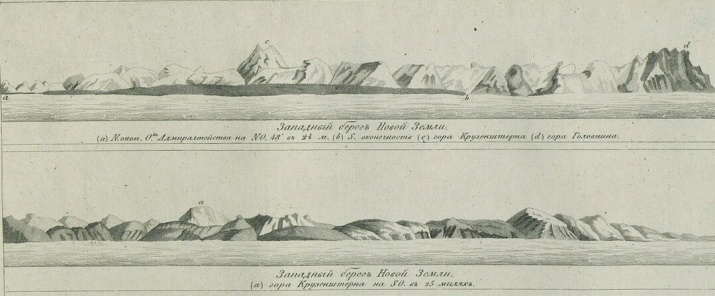
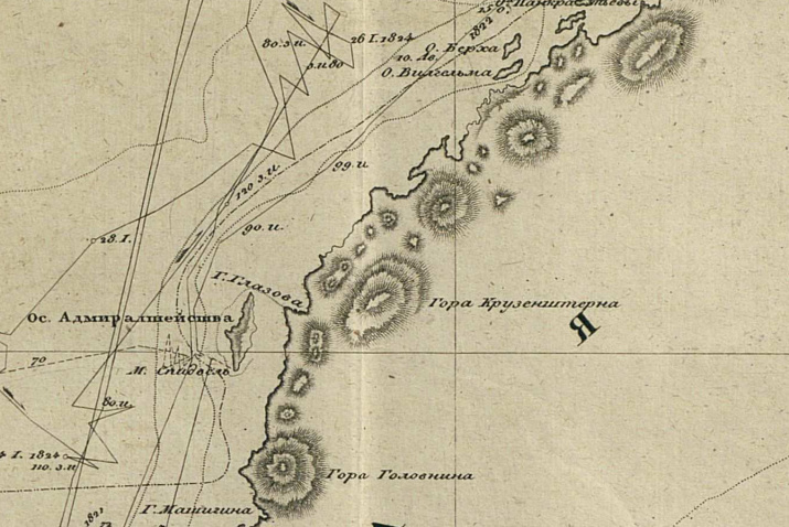
Mount Kruzenshtern is the highest point of the Novaya Zemlya archipelago, it reaches a height of 1547 meters. It is located on Severny Island, its coordinates are 75°10.5'N and 57°49.6'E.
The navigator and geographer, Arctic explorer Fyodor Litke gave named it in 1822. At seven o 'clock in the evening on August 9 , 1822 , he made the following entry in his diary:
"From the Admiralty Island, the coast inclines more to the east. The mountains are getting lower, but steeper, and they are almost completely covered with snow. The shore has a very uniform appearance. There were only a few glaciers and one very tall, tent-like mountain lying in latitude 74°30’. It is called the Mount Kruzenshtern - a name as glorious in the academic world, as precious for everyone who knows how to appreciate the virtues connected with the nobility of the soul..."
On this day, the brig Novaya Zemlya, under the command of the future Admiral, President of the Academy of Sciences and founder of the Russian Geographical Society, reached the extreme land area seen by sailors in the last expedition of 1821. Noting the outstanding mountain, Lieutenant Commander Litke led the brig further north. In 1828, having processed the materials of all the expeditions of 1821-24, Litke published the book "A four-time trip to the Arctic Ocean, made by order of Emperor Alexander I, on the military brig Novaya Zemlya in 1821, 1822, 1823 and 1824 by Fleet Lieutenant Commander Fyodor Litke".
The Mount Kruzenshtern on the map of 1828 is indicated in the place corresponding to the description - northeast of Admiralty Island, at the latitude of Glazov Bay. Despite the fact that the discoverer of the Mount Kruzenshtern, F.Litke, in 1828 unambiguously determined its location on the final map of his four-year expeditions to Novaya Zemlya, during the XIX century on maps published in Russia and abroad the mountain was placed in various places. For example, in 1836, in St. Petersburg, according to the results of the expedition of P. Pakhtusov in 1834-1835 the “Survey Map of Novaya Zemlya" created by August Tsivolka was published. On the map, the Mount Kruzenshtern is shown in the same place as on Litke's maps. But in 1843, the Hydrographic Department of the Maritime Ministry published a "General map of a part of the Arctic Ocean and the Kara Sea with the Novaya Zemlya archipelago". On it, the Mount Kruzenshtern is depicted much to the north, as well as on the map of Novaya Zemlya, published by the Hydrographic Department of the Maritime Ministry in 1871.
After the 1917 revolution, the toponym "Mount Kruzenshtern" disappears from the maps of Novaya Zemlya. It can not be found on the Hypsometric Map of Novaya Zemlya published in 1934 by the USSR Academy of Sciences. It is not present on modern topographic maps of Novaya Zemlya either. Moreover, the ”List of geographical names of objects of the Arkhangelsk Region registered in the State Catalog", the most complete list of names of geographical objects of Russia established by legislation, also lacks the toponym "Mount Kruzenshtern".
As it was established, hydrographers and surveyors of the Northern Hydrographic Expedition were engaged in mapping the archipelago in the 1950s. The history of their selfless work is full of glorious and tragic pages, and the results of their work can still be found on the shores and in the most inaccessible areas of Novaya Zemlya.
In 1958, the submission of the Command of the Northern Hydrographic Expedition to assign names to unnamed geographical objects on Novaya Zemlya was considered by the Scientific Council of the Branch of the Geographical Society in Arkhangelsk. After that, the Arkhangelsk Regional Executive Committee approved the new names. Among others, the highest point of Novaya Zemlya received its name. It was given the name "Mount Northern Hydrographic Expedition" - in memory of the works of the Northern Hydrographic Expedition. It is marked on some modern nautical charts.
However, for some reason, this name wasn't popular on topographic maps of the archipelago. And it also does not appear in the "Handbook on the History of Geographical Names on the coast of the USSR" published in 1985. These facts allow us to consider the mountain nameless.
In 2022, it will be 200 years since the Mount Kruzenshtern appeared on the map of Novaya Zemlya thanks to the famous Russian Admiral Fyodor Litke. The scientific director of the Complex Expedition of the Northern Fleet and the RGS, Colonel Sergey Churkin, launched work on the restoration of the mountain's historical name justified by the Federal Law of December 18, 1999 “About the names of geographical objects" . In February 2022, the necessary set of documents with a proposal to return the mountain to its former name was approved by the Arkhangelsk Regional Assembly of Deputies and sent to the Ministry of Defense of the Russian Federation.
The return of the famous name of Ivan Kruzenshtern to the map of Novaya Zemlya in the year of the 200th anniversary of the discovery of the mountain named after him, as well as the 225th anniversary of the birth of its discoverer Admiral, President of the Academy of Sciences and founder of the Russian Geographical Society, will certainly give a new impetus to research of history of the Russian Arctic development.
Based on the materials collected by Sergey Churkin


